Stratford-upon-Avon
Lots of locks to a Historic Town
Scroll down to learn more
We are currently running some special offers, Click here for more info
These route suggestions are offered in good faith and to the best of our knowledge. It is up to you to decide on your own stops and to ensure you return to the base at the agreed time.
we recommend you also check for current stoppages on the CRT website that may affect your choice of route
Napton to Stratford-Upon-Avon
Pictures: click for a bigger image


Napton to Long Itchington
Pictures: click for a bigger image

Points of Interest
Napton-on-the-Hill
Napton-on-the-hill, the home village of Napton Narrowboats.
Pictures: click for a bigger image


Location: On Google Maps
Best Access From: Bottom of the Napton Locks, Click for Route Map.
- Postcode: CV478HX
Points of Interest in Napton-on-the-Hill
The Kings Head Napton
The Kings Head is ideally situated on the A425 between Southam and Daventry.
It is just a 5 minute walk from Napton Narrowboats
Pub Opening Times
Mon to Thursday 4.00 pm to 11:00pm
Fri & Sat 12.00 noon to 11:00pm
Sunday 12.00 noon to 8.00pm
Food Available
Mon to Thursday 4.00 pm to 8.30pm
Fri & Sat 12.00 noon to 8.30pm
Sunday 12.00 noon to 6.00pm
Reservations highly recommended. Please call 01926 839739.
Pictures: click for a bigger image

Location: On Google Maps
Best Access From: Bridge 109, Click for Route Map.
- Postcode: CV478NG
Napton Village Stores
Including a Post Office, and offering a range of local produce. Includes a cafe.
Napton Village Stores is owned and run by a local family, acquired in January 2014, offering a friendly welcome to local regulars and visitors to the village alike. The store itself had a complete refresh and the �Napton Kitchen� was introduced � a home from home place to enjoy a hot drink and a wealth of homemade foods to eat in or take away. Our deli fridge will tempt you daily and we also offer outside catering � we can bring the Napton Kitchen to your home or office.
Pictures: click for a bigger image

Location: On Google Maps
Best Access From: Folly Lane Bridge, Click for Route Map.
- Postcode: CV478LR
Napton Cidery
Craft Cider & Perry
Napton Cidery is an award-winning, family-run craft cidery based in Warwickshire. Buy our selection of naturally vegan & gluten-free ciders & perry online. Learn more about our unique cider tour & tasting experiences, around Warwickshire, Coventry & Birmingham.
Pictures: click for a bigger image

Location: On Google Maps
Best Access From: Bottom of Napton Locks, Click for Route Map.
- Postcode: CV478NY
The Folly Pub
The Folly Inn, Napton is a family and dog friendly, warm, local pub with excellent homemade food.
Pictures: click for a bigger image

Location: On Google Maps
Best Access From: Bottom of Napton Locks, Click for Route Map.
- Postcode: CV478NZ
Boat Inn
Canalside pub & restaurant above Stockton Locks.
Food served Wednesday to Sunday
Pictures: click for a bigger image


Location: On Google Maps
Best Access From: Bridge 21, Click for Route Map.
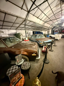
Blue Lias pub
With new owners, the Blue Lias is now "Fat Bobs at the Blue Lias", a classic vehicles themed pub with display vehicles and regular events and meets.
Pub, restaurant, and on weekends the Pitstop cafe serving breakfasts.
Pictures: click for a bigger image
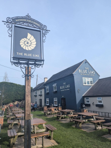
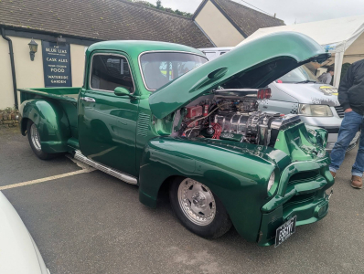
Location: On Google Maps
Best Access From: Bridge 23, Click for Route Map.
- Postcode: CV478LD
Long Itchington
Location: On Google Maps
Best Access From: two boats public house, Click for Route Map.
Points of Interest in Long Itchington
Two Boats Pub
At The Two Boats you can enjoy a great selection of real ales, fine wines, bottled and draft beers.
Pictures: click for a bigger image

Location: On Google Maps
Best Access From: Bridge 25, Click for Route Map.
- Postcode: CV479QZ
The Cuttle Inn
Canalside pub with large garden
Pictures: click for a bigger image

Location: On Google Maps
Best Access From: Bridge 25, Click for Route Map.
Duck on The Pond
Pub & Restaurant in Long Itchington.
'Cinnamon Arch' also offer their delicious Indian food at the Duck on the Pond, to dine in as well as takeaways.
Pictures: click for a bigger image

Location: On Google Maps
Best Access From: Bridge 25 - 1/2 mile walk, Click for Route Map.
Buck and Bell Pub
A Family friendly village pub offering a warm welcome a wide selection of drinks
Pictures: click for a bigger image

Location: On Google Maps
Best Access From: Bridge 25 - 1/2 mile walk, Click for Route Map.
Harvester Pub
Village inn serving real ales and pub grub including locally sourced steaks in its small restaurant.
Location: On Google Maps
Best Access From: Bridge 25 - 1/2 mile walk, Click for Route Map.
Green Man Pub
Pub in Long Itchington
Pictures: click for a bigger image

Location: On Google Maps
Best Access From: Bridge 26A, Click for Route Map.
- Postcode: CV479PW
Holy Trinity Church, Long Itchington
Location: On Google Maps
Best Access From: Bridge 25/26/26A, Click for Route Map.
- Postcode: CV47 9FN
Co op Shop
Village shop for food & drink
Location: On Google Maps
Best Access From: Bridge 25, Click for Route Map.
Long Itchington to Warwick
Points of Interest
Radford Semele
A short walk from the Canal, this village makes a nice stop off for the night.
Location: On Google Maps
Best Access From: Bridge 34, Click for Route Map.
Points of Interest in Radford Semele
The White Lion Pub
The White Lion is a smart, historic country pub in the village of Radford Semele
Pictures: click for a bigger image

Location: On Google Maps
Best Access From: Bridge 34, Click for Route Map.
- Postcode: CV311TE
Best One Convenience Store
29-31 Lewis Rd, Radford Semele, Semele
Location: On Google Maps
Best Access From: Bridge 34, Click for Route Map.
- Postcode: CV311UQ
Sydenham
Location: On Google Maps
Best Access From: Bridge 27, Click for Route Map.
Points of Interest in Sydenham
The Fusilier Pub
"A local pub like no other". The Fusilier is a fantastic traditional pub situated right at the heart of the local Sydenham community in Leamington Spa.
Pictures: click for a bigger image

Location: On Google Maps
Best Access From: Bridge 37, Click for Route Map.
- Postcode: CV311NJ
Sydenham Shops & Takeaway
A Small cluster of Takeaways & a convenience store & post office within a stone's throw of the canal. Chinese, Indian, and Fish & Chips
Royal Leamington Spa
Royal Leamington Spa is a beautiful town located in the heart of Warwickshire.
Pictures: click for a bigger image

Location: On Google Maps
Best Access From: Bridge 40, Click for Route Map.
Points of Interest in Royal Leamington Spa
Pharmacy
Location: On Google Maps
Best Access From: Bridge 40, Click for Route Map.
Morrisons
Large supermarket a short walk from the canal
Location: On Google Maps
Best Access From: Towpath moorings outside, Click for Route Map.
Sainsburys, Leamington
Large Supermarket
Location: On Google Maps
Best Access From: Bridge 43, Click for Route Map.
Lidl, Leamington
Canalside supermarket
Location: On Google Maps
Best Access From: Canalside from Towpath, Click for Route Map.
The Moorings at Myton
Stylishly revamped pub by the canal, with real ales and a Modern British menu, plus outside tables.
Pictures: click for a bigger image

Location: On Google Maps
Best Access From: Bridge 43, Click for Route Map.
- Postcode: CV313NY
Co op, Leamington
Location: On Google Maps
Best Access From: Bridge 40, Click for Route Map.
- Postcode: CV312DP
Tesco - Warwick
Supermarket near the canal
Location: On Google Maps
Best Access From: Bridge 46, Click for Route Map.
Sainsburys, Warwick
Location: On Google Maps
Best Access From: Bridge 51, Click for Route Map.
Cape of Good Hope pub
Pictures: click for a bigger image

Location: On Google Maps
Best Access From: Cape Moorings, Click for Route Map.
Warwick to Lowsonford
Points of Interest
Hatton Locks
A flight of 21 locks spread over less than 2 miles. One of the well known historical features of the canal system, often known as the "Stairway to Heaven"
Pictures: click for a bigger image

Location: On Google Maps
Best Access From: Towpath, Click for Route Map.
The Hatton Arms
A dog-friendly historic 18th-century pub, an old coaching inn, overlooks the Hatton locks with amazing views from the spacious beer garden and outdoor dining terrace.
Inside, you�ll find cosy corners with a warm fire in winter, and larger spaces perfect for special occasions.
Pictures: click for a bigger image

Location: On Google Maps
Best Access From: Footpath from canal bridge 4 locks down, Click for Route Map.
Shrewley Tunnel
Canal tunnel under Shrewley village, unusual in having one tunnel for the boat, and a separate, higher tunnel for the horse!
Pictures: click for a bigger image

Location: On Google Maps
Best Access From: The Canal!, Click for Route Map.
Tom O' The Wood, Rowington
A country pub located in the picturesque village of Rowington alongside the Grand Union canal.
This stunning pub run by Chris & Charlie, has a passion for serving good, fresh, homemade food, which is locally sourced from local suppliers & farms.
Tom O� The Wood is a dog friendly pub, that caters for all.
Pictures: click for a bigger image

Location: On Google Maps
Best Access From: Bridge 63, Click for Route Map.
Kingswood Junction
The junction of the Grand Union and Stratford-upon-Avon canals. Turn south here for Stratford. 9 more locks (single this time) will take you to Lowsonford
Location: On Google Maps
Best Access From: The Canal!, Click for Route Map.
Lowsonford
A small village in Warwickshire, home to the Fleur de Lys pub, making a nice nightime stop.
Location: On Google Maps
Points of Interest in Lowsonford
Fleur de Lys Pub
This quaint, white-washed rustic, oak-beamed inn has an open fire and a peaceful, canalside garden. Dog friendly, family friendly & famous for its award-winning pies.
Pictures: click for a bigger image

Location: On Google Maps
Best Access From: 'New Road' bridge, Click for Route Map.
Lowsonford to Stratford-upon-Avon
Points of Interest
Wootton Wawen
A village in mid-western Warwickshire, about 20 miles (32 km) from Birmingham and about 6.5 miles (10 km) north of Stratford-upon-Avon. The older part of the village straddling the A3400 is designated as a Conservation Area because of its open, rural character and many historic buildings.
Location: On Google Maps
Best Access From: Wootton Wawen Aqueduct, Click for Route Map.
Points of Interest in Wootton Wawen
The Navigation Inn
A canalside pub in Wootton Wawen, serving great food with stunning waterside views
The General Store, Wootton Wawen
Handy shop 10 minutes walk from the canal, open every day.
Location: On Google Maps
Best Access From: Wootton Wawen Aqueduct, Click for Route Map.
The Bull's Head, Wootton Wawen
Exquisite, authentic Thai cuisine & the service you deserve, in a delightful, old-world heritage pub.
With great ales, drafts, crafts & wine, as well as some of your Great British pub grub favourites.
Online booking available
Pictures: click for a bigger image

Location: On Google Maps
Best Access From: Wootton Wawen Aqueduct, Click for Route Map.
Edstone Aqueduct
At 475 feet (145 m), Edstone is the longest cast iron aqueduct in England. The towpath is set level with the base of the trough, which is a somewhat unusual design feature and makes for an interesting viewpoint of the boats crossing the valley.
,
Pictures: click for a bigger image

Location: On Google Maps
Best Access From: Boating over the top of it.., Click for Route Map.
Stratford-Upon-Avon
The town is a popular tourist destination owing to its status as birthplace of the playwright and poet William Shakespeare. The Royal Shakespeare Company resides in Stratford's Royal Shakespeare Theatre, one of Britain's most important cultural venues.
There are lots of shops, pubs, restaurants and takeaways in town.
Pictures: click for a bigger image


Location: On Google Maps
Best Access From: Bancroft Basin, Click for Route Map.
- What3Words: letter/gather/raced
Points of Interest in Stratford-Upon-Avon
Shakespeare's Birthplace
Half-timbered shrine to the Bard, with memorabilia, period furnishings and changing exhibitions.
Location: On Google Maps
Best Access From: Bancroft Basin, Click for Route Map.
Royal Shakespeare Theatre
The main venue in Stratford-upon-Avon for the performance of Shakespeare's (an other's) plays. Home of the Royal Shakespeare Company.
Pictures: click for a bigger image

Location: On Google Maps
Best Access From: Bancroft Basin, Click for Route Map.
Guidebooks / Maps

Pearson's Guide: South Midlands Companion
With the Warwickshire Ring at its heart, this Canal Companion covers the canal network to the south and east of Birmingham. Routes covered include: Grand Union Canal (Braunston-Birmingham); Birmingham & Fazeley Canal; Coventry Canal; Oxford Canal (Hawkesbury-Napton; Ashby Canal; Worcester & Birmingham Canal (Tardebigge-Birmingham); Trent & Mersey Canal (Derwent Mouth-Fradley) and Stratford upon Avon Canal.
Contact Us
- Phone:
- +44 (0)1926 813644 (Calls may be recorded for monitoring purposes)
- Email:
- enquiries@napton-marina.co.uk
- Open:
- March to October - 8:30am to 5:00pm (BST) - Monday to Saturday.